

Section: New Results
Optical imagery for remote sensing
Phase Field-Higher Order Active Contours for Object Modelling and Image Segmentation
Participants : Ikhlef Bechar, Josiane Zerubia [contact] .
This work is done in collaboration with Dr Ian Jermyn of Durham University (United Kingdom) and was funded by a contract with the EADS foundation [http://www-sop.inria.fr/ariana/Ikhlef.Bechar/hoacs/index.html ].
The problem of object segmentation from imagery is an essential preliminary task for many applications (target recognition, automated navigation, organ segmentation in medical imaging, etc). The problem of adding prior knowledge about objects to the image segmentation process has received a lot of interest since recently, and active contours [38] provide us with such a tool.
We consider a new class of active contours called Higher Order Active Contours (HOACs) introduced initially in [41] , and which consider an optimal contour as the one which minimizes an energy involving three additive terms; namely the length of a contour, its area and a term of interaction between all possible pairs of its points via an interaction function . The three terms being weighed by means of three scalar parameters. The main advantage of HOACs over traditional segmentation methods is that they offer an unprecedented means for including shape prior about an object via the interaction function .
The HOAC set up has been applied successfully to various object extraction problems such as the extraction of networks [40] , circular shapes [37] , etc, using a specific family of the 's. Our main task in the framework of this project is to extend their work to more general shapes.
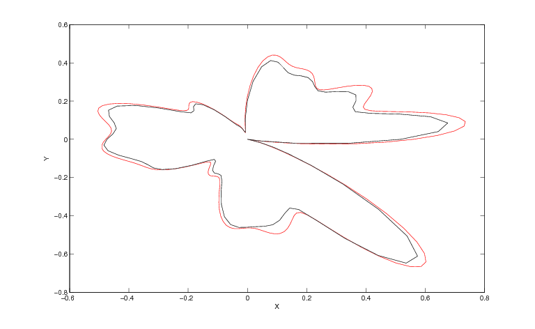
Our contributions so far have been in the numerical computation of the optimal HOAC parameters for a given shape. We have shown indeed that the HOAC energy can be fully made linear with respect to , which then makes it easy to solve for numerically (cf. Fig.6 ). This is achieved by first choosing a linear basis to represent and using K-K-T (Karush-Kuhn-Tucker) optimality criteria to express the fact that a target contour is a local minimum of the energy. Consequently, looking for the optimal values of the coefficients for a given shape amounts first to solve an eigen value problem, and second, to find the linear combinations of the found eigen vectors that satisfy both K-K-T minimality criteria. The computation being carried out in the Fourier domain for sake of computational efficiency. We are currently testing the proposed model on simple shapes such as the butterfly one shown in figure 6 .
|


Optimization of the compression-restoration chain for satellite images
Participants : Mikael Carlavan, Laure Blanc-Féraud [contact] .
This project involves the French Space Agency (CNES) and the CESBIO, on collaboration with TAS and I3S (Marc Antonini).
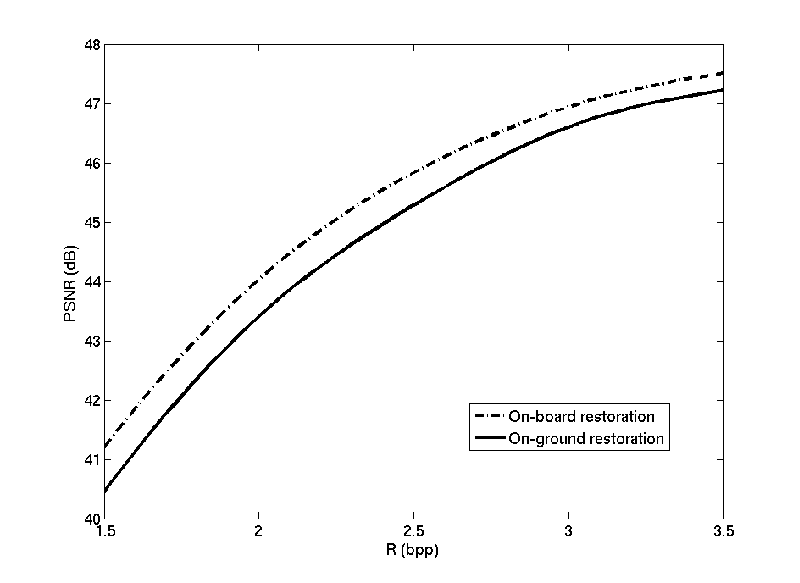
This work concerns the study of the optimal imaging chain in the context of satellite imaging. The main goal of this study is to propose a new method to address the problem of decoding-deconvolution-denoising and consists in a characterization and optimization of the compression/restoration processes considering the instrumental characteristics (FTM, noise, sampling). A theoretical study first showed that current processes of compression and restoration are better fitted if the restoration is performed on-board before the compression. Indeed, current restoration algorithm is designed to remove the blur and the instrumental noise but does not take into account the coding noise, and it is well-known that compression algorithms do not perform properly on noisy data. More generally, we concluded that the image should be the closest possible to the real image before the step of coding, encouraging, thus, to move the restoration step on-board before the compression. Figure 7 shows the global distortion w.r.t. the coding rate if the restoration step is done either before (on-board) or after (on-ground) the compression. We see that using an on-board restoration leads to a quality improvement of the final image regardless the coding rate. For example, at the usual coding rate of 2.5 bits/pixel, using an on-board restoration improves the quality of the final image about 0.5 dB.
|
Aerial Image Restoration
Participants : Daniele Graziani, Laure Blanc-Féraud [contact] .
This project involves as partners: ATE, Coreti, and Gilles Aubert from the J.A.D. Laboratory at the University of Nice Sophia Antipolis.
The goal of the project is to built an airborne camera system, and our part is to process aerial images provided by ATE: restoration, microscanning, video, color images. We investigate a convex variational framework to compute high resolution images from a low resolution video. We analyze the image formation process to provide a well designed model for warping, blurring, downsampling and restoration. The microscanning is modeled as a convex minimization problem, which is solved with a domain decomposition technique based on the recent work of M. Fornasier, A. Langer and C. Schonlieb. ("A convergent overlapping decomposition method for total variation Minimization", Numeriske Math. to appear), which allows parallel computing and a realization of a real time algorithm.
Contribution of object recognition on forest canopy images to the building of an allometric theory for trees and natural, heterogeneous forests
Participants : Jia Zhou, Xavier Descombes, Josiane Zerubia [contact] .
This work is done in collaboration with Dr. Pierre Couteron and Christophe Proisy at IRD, UMR AMAP, Montpellier.
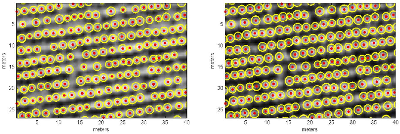
Individual tree detection methods are more and more present, and improve, in forestry and silviculture domains with the increasing availability of satellite metric imagery. Automatic detection on these very high spatial resolution images aims to determine the tree positions and crown sizes. The mathematical model based on marked point processes has showed advantages w.r.t. several individual tree detection algorithms for plantations. We used this detection method to analyze natural mangrove forests in French Guiana, eucalyptus plantations in Brazil, and other types of tropical forests. The simulated optical images were also used to improve the method and calibrate the detection parameters. To analyze a eucalyptus plantation in Brazil [23] , we used 2 optical images acquired by the WorldView-2 satellite. A tentative detection simultaneously with 2 images of different dates (multi-date) was tested for the first time, which estimates individual tree crown variation during these dates. In this work, we tried to find the trees localizations and crown sizes in order to provide a plantation map, and estimate the tree crown growth during the period between 2 images, and compared these results with the field measurements and expected dynamics of corresponding populations. An example of multi-date detection result is showed in figure 9 .
|
The detection method was also applied on simulated optical DART (Discrete Anisotropic Radiative Transfer) images, where exact field inventory could be provided on large surfaces. We assessed the detection results with these “ground-truth” maps.